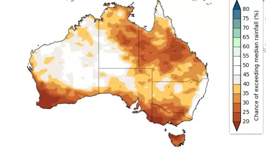
Australians should expect drier and warmer conditions this spring, with an increased risk of bushfires across parts of the country.
El Nino is upon us, with the US Government body responsible for predicting climate changes last week predicting a 95% probability that the weather eve will last through to February 2024 “with far-reaching climate impacts.”
The last time an El Niño was in effect was 2019-20, when the Black Summer fires devastated the east coast of Australia.
Considered the largest fire in Australian recorded history, the fires destroyed millions of hectares of forest and caused the death of 3 billion native animals.
They even led to a ‘deep, long-lived hole in the ozone layer.’
Yesterday, the Australasian Fire Authorities Council (AFAC) published its Spring Bushfire Outlook.
The outlook has put residents in five states and territories on high alert, predicting an increased risk of bushfires in large areas of the Northern Territory, Queensland and NSW, and regions in Victoria and South Australia.
Communities in these regions are encouraged to prepare for bushfires and monitor local conditions.
Bushfire season typically runs from December to May in southern Australia, May to October in northern Australia and August to March in central Australia.
In June, Wood Central reported a ‘catastrophic bushfire season’ threat based on observed pastoral conditions across Queensland, WA and Victoria.
Fire authorities say, “Rampant vegetation growth through parts of Australia heightens this year’s chance of bushfires.”
It comes as the Australian BOM highlights the fire risk is highest for September and October – coinciding with increased dry conditions.

Before lessening in October to December with expected rains.
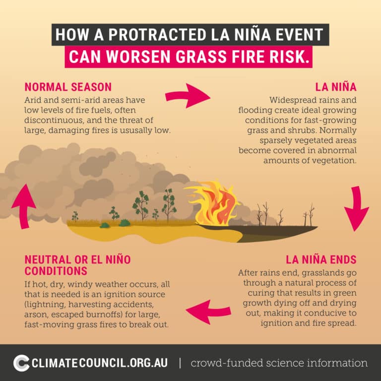
According to the CEO of AFAC, Rob Webb, recent wet years have triggered excessive vegetation regrowth, increasing the fire risk, particularly in grassland areas.
“We often think of La Niña, and we equate it with flood conditions across the eastern part of Australia, but what it also brings is large amounts of grass growth,” he said.
“What we’ve seen over three years is a large amount of fuel over central and northern New South Wales, Queensland, and the Northern Territory.”
“So eventually, when the climate dries out, grass fuel tends to become like tinder, increasing the risk.”
Australia’s most intense bushfires are often associated with forest fires.
But grass fires are equally dangerous, according to the Climate Council, as they can start easily and spread quickly – up to three times faster than bushfires.

High fuel loads, particularly grasses, have caused fires to rip through the Top End and Central Australia over the past week, with the ABC reporting that authorities expect 80 per cent of the Northern Territory to burn from bushfires by March.
The AFAC Spring Bushfire Outlook
What’s the bushfire outlook for NSW?
Residents in central and northern NSW should expect an increased risk of fire this spring. That’s because of high fuel loads and the forecast of warmer and drier conditions.
Drier-than-average conditions and frost curing (where frost dries out grass and leaves) in these areas can mean an early start to the bushfire danger period.
“In the event of fires and windy weather, these high grass fuel loads can support intense and fast-spreading grass fires,” the report said.

There’s also a greater fire risk for those around the Sydney basin, parts of the coast and north of the Hunter because of the forecast of warmer and drier conditions.
The outlook also said high forest fuel loads are evident in parts of the coast and ranges unaffected by the 2019-20 fires.
What’s the bushfire outlook for Victoria?
Victorians should expect a warmer spring and an earlier start to the high-risk bushfire season after three years of La Niña and lower fire-risk seasons.
Those in the east, particularly in the Gippsland region, are warned to expect a higher-than-normal potential for forests to carry fire, especially around coastal communities close to bushland where vegetation was unburnt or lightly burnt during the 2019-20 fires.
The Gippsland area has been impacted by the Victorian Government’s decision to close forest harvesting in State Forests.
In June, Justin Law, the former Managing Director of Forest and Wood Communities Australia, warned that the ban could lead to a reduction in volunteer capacity to help fight bushfires.
Wood Central spoke to an industry source who said the Victorian Government has yet to finalise its arrangements with existing contractors they previously relied upon as part of their response capacity.

For those in central, western and northern Victoria, there is a high likelihood that the bushfire season of 2023-24 will start a lot sooner.
As reported by Wood Central earlier this month, AI is being deployed in plantation estates in Eastern Victoria and the Green Triangle to assist with the early detection of fires.
Wood Central understands that these AI-powered cameras will not just protect the plantation estate – but all land within the camera’s lens.
These plantation assets will also complement similar assets the Government has co-funded with the Fed Government.
What’s the bushfire outlook for South Australia?
The report says the outlook for fire danger has increased from below average to above average for spring across much of the southern half of South Australia.
According to the report, above-average rainfall has quickly changed to below-average rainfall and soil drying.
There is also an increased fire risk for grassland in the Green Triangle and Mallee Heath areas across the southern part of the state, approaching the Victorian border.
In February, Wood Central Senior Editor Jim Bowden reported on the 40th anniversary of the Ash Wednesday fires – which ripped through parts of South Australia and Victoria in 1983.
“These factors raise expectations of an early start to the 2023 fire danger season,” the report said.
What’s the bushfire outlook for Queensland?
The northern and central Queensland grasslands, timber country and savannah grasslands will likely have elevated fire potential in late spring.
“The combination of drying fuels, forecast below average rainfall and above average temperatures is likely to bring locally intense bushfires that may be destructive across parts of Queensland as vegetation becomes flammable during the spring months,” the report said.
What’s the bushfire outlook for the Northern Territory and the rest of the country?
In June, a burst of heavy rain in central Australia and the Barkly region means already above-average grass fuel loads will increase even more.
This, combined with minimal fire scar coverage (where land is left blackened after a fire burns through), above median temperatures and dry, windy conditions predicted for spring, means an increased fire risk for the Barkly, Tanami, Alice Springs and Lassiter forecast regions.
An average fire potential is also predicted for the Top End, Katherine and Arnhem districts.
For Tasmania and the Australian Capital Territory, an average bushfire risk is predicted for spring.
In Western Australia, an increased fire risk for the Pilbara is unlikely.
The bushfire risk could increase for the Kimberley region as the weather becomes drier and warmer.
Download the NOBURN AI App ahead of Bushfire season.
Communities are encouraged to use the NOBURN app – which helps fire authorities predict future fire risks.
‘NOBURN’, short for the National Bush Fire Resilience Network, has been developed by researchers from USC and the Australian Institute for Machine Learning at the University of Adelaide.
According to Dr Sam Van Holsbeek, the app can predict danger using nothing more than a smartphone.
“We want the community to go out into the forest and collect evidence to monitor forest fuel in our forested locations,” he told Sky News Australia last month.
The information creates a hazard rating for the different forests and fuels to determine if better predictions of bushfires can occur.
As Australia prepares for another menacing bushfire season, Dr Van Holsbeek said being prepared is critical.
“The app encourages people out and about in their local forests to take photos and tell us more about the forest and fuels,” Dr Van Holsbeek said.
“So we want people to go into the forest, snap a pic and help predict.”


