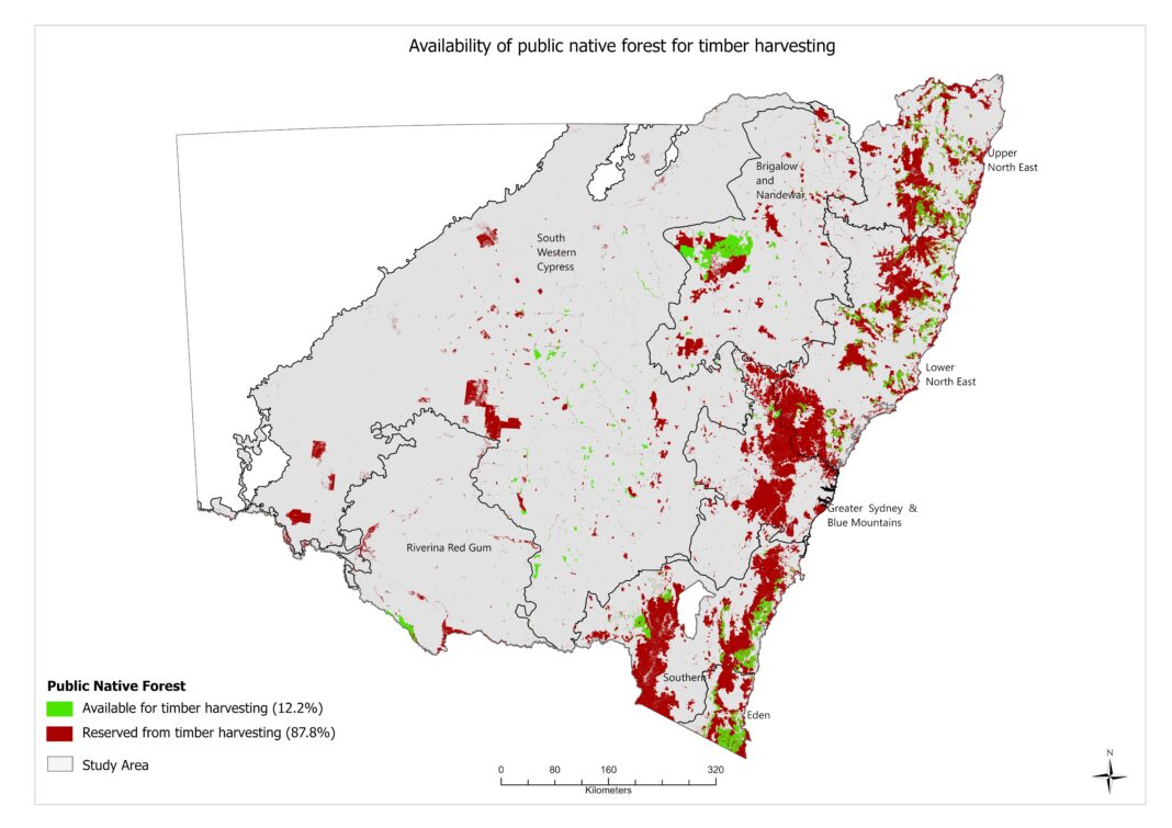
Wood Central’s exclusive release of spatial mapping data sheds new light on the current state of NSW public native forests.
According to spatial mapping provided by the NSW DPI Forest Science unit and commissioned by Timber NSW, 88% of these forests are reserved from timber harvesting, leaving just 12% available for commercial harvesting.
This information is crucial for voters to understand the true extent of current forest conservation efforts, and to evaluate the various policy proposals put forth by the contending parties.
In another Wood Central exclusive, a recently released Ernst & Young report exposed the potential shortcomings of the plan for a Great Koala National Park.

The report argues that such a park, while well-intentioned, may not be the most effective or feasible solution for koala conservation.
Spatial mapping data: unveiling the complex landscape
To provide a more comprehensive understanding of the situation, Wood Central has provided access to spatial maps for various regions within NSW. Including:
- Brigalow Nandewar
- Eden
- Riverina Red Gum
- Southwestern Cypress
- Southern
- The Lower North East
- The North East
- The Upper North East
All areas represent major public native forest areas in NSW and provide, for the first time, a true picture of timber harvesting in NSW public native forests.
For the purpose of the maps, the red shaded area represents ‘no-go’ zones for harvesting while the green shaded area represents areas where harvesting is permitted.
The mapping reveals a complex landscape, where the vast majority of public native forests are already protected from timber harvesting.
The importance of riparian corridors and gully protections
The mapping also emphasises the importance of riparian corridors and gully protections.

These protection zones play a critical role in maintaining the overall health of the ecosystem and supporting biodiversity. They serve as vital links between different habitats, allowing wildlife to move more freely and access essential resources, such as food and water.
Understanding riparian corridors and gully protections
A riparian corridor is a vegetated area adjacent to streams, rivers, or other bodies of water, providing essential habitat and ecological functions. In forestry, gully protection refers to the conservation of erosion-prone landforms by maintaining vegetation cover and implementing practices to prevent soil disturbance, thereby preserving water quality and supporting wildlife habitats.
Focus on Eden and the North-East
The Eden and North-East regions, both long-standing political touchpoints, highlights the importance of riparian corridors and gully protections in native forest management.

Identified as red ferns amongst the highlighted green, these areas effectively act as forestry buffers and are essential for conserving threatened species, and for maintaining the overall health and resilience of the local ecosystem.

The mapping offers a crucial insight into the complexities of native forest conservation and management in NSW.
The data reveals that a significant portion of public native forests are already protected from timber harvesting, emphasising the importance of riparian corridors and gully protections for maintaining ecosystem health and supporting biodiversity.
As the NSW state election approaches, this information is invaluable for voters seeking to make informed decisions regarding forest management policies.
Ultimately, striking a balance between sustainable timber harvesting and robust conservation efforts is essential for the long-term well-being of both the environment and the communities that depend on it.


